Original: $32,995.00
-65%$32,995.00
$11,548.25The Story
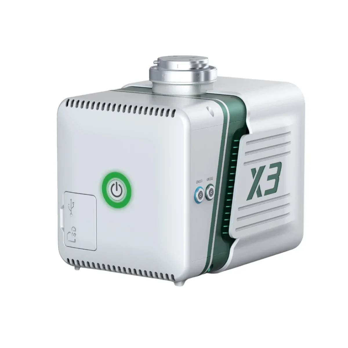
Freefly Flux O1: NDAA-Compliant LiDAR Payload for High-Density Point Cloud Collection on Freefly Aircraft
For survey teams and infrastructure operators working on sites where component sourcing and data security are non-negotiable, the Freefly Flux O1 answers the question that has historically been hardest to answer in the airborne LiDAR market: where do you find Ouster OS1 performance in a payload that meets federal procurement requirements and doesn't lock you into a software subscription?
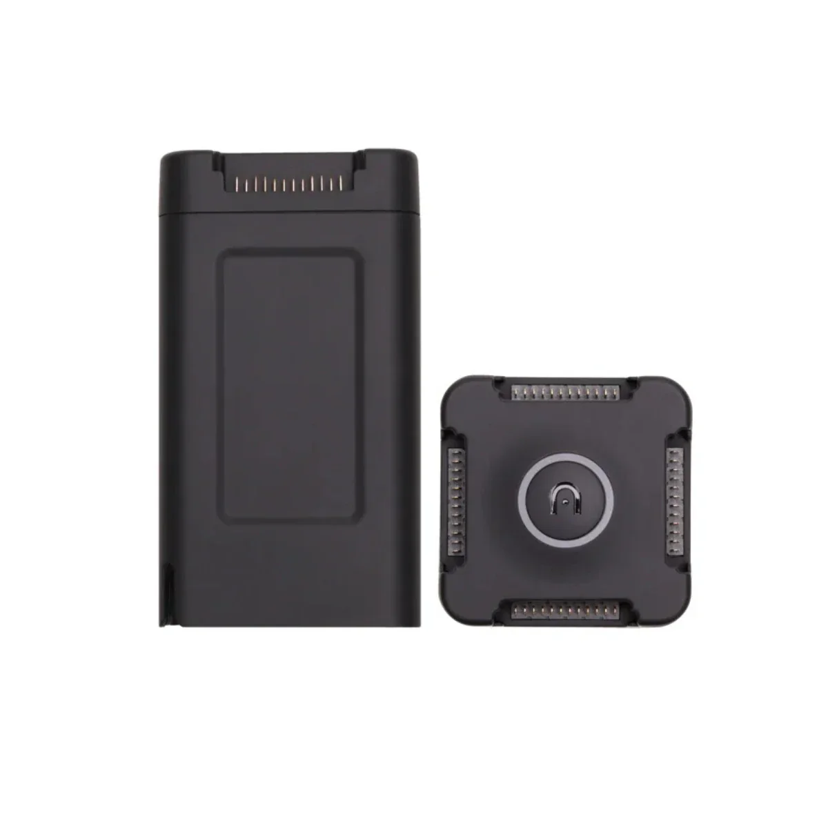
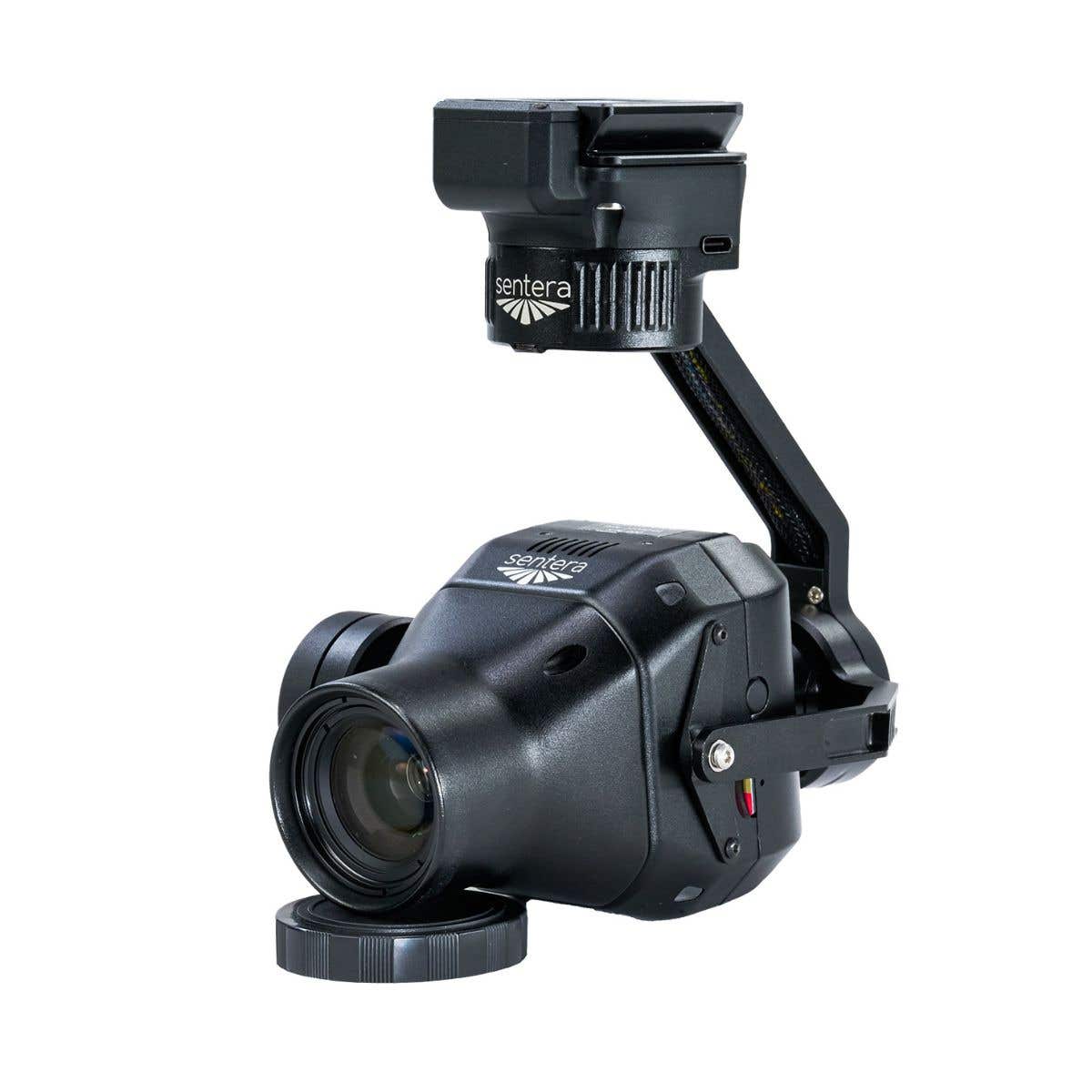
At 633 grams — the lightest in Freefly's Flux lineup — the O1 integrates via Smart Dovetail with the Freefly Astro, Astro Max, and Alta X Gen2, delivering 5,242,880 points per second across a 360°×42.4° field of view at ±3 cm accuracy and up to 200 m range. NDAA compliant, FCC approved, and exporting directly to LAS or LAZ through the free Freefly Flow iPad app, it is a system built around operational clarity rather than software dependency.
Key Features and Benefits
- Ouster OS1 scanner: 5,242,880 points per second at ranges up to 200 m.
- 360°×42.4° FOV: full horizontal sweep with vertical coverage in a single pass.
- ±3 cm accuracy: ±0.5 cm precision for survey-grade point cloud data collection.
- Dual laser returns: reliable data capture through vegetation and complex surfaces.
- Dual U-blox X20 GNSS: full-band L1/L2/L5/L6 receivers support PPK post-processing.
- Ximea 20MP RGB camera: colorizes point cloud data in the same mission pass.
- 633 g payload weight: lightest in the Flux lineup for minimal aircraft endurance impact.
- Smart Dovetail interface: tool-free integration with Freefly Astro, Astro Max, and Alta X Gen2.
- LAS and LAZ export: standard output formats with no software subscription required.
- NDAA compliant: approved for government, defense, and critical infrastructure procurement.
The O1's dual U-blox X20 full-band GNSS receivers, covering L1, L2, L5, and L6, form the backbone of a PPK workflow that processes on-device without cloud infrastructure or recurring licensing costs.
The integrated Ximea 20MP RGB camera captures colorized point cloud data in the same pass, and dual laser returns produce clean, reliable data through vegetation, complex facades, and mixed-surface terrain.
For organizations deploying Freefly platforms on government contracts, utility corridor inspections, or critical infrastructure assessments, the Flux O1 represents a procurement-ready LiDAR solution that fits the aircraft they already operate and the compliance requirements their projects already impose.
A Compliant LiDAR Solution That Fits the Freefly Ecosystem
The Flux O1's integration story is built on specificity. The Smart Dovetail mount provides direct, tool-free attachment to the Astro and Astro Max with no adapters required, and the two quick-release GNSS mounts included in the box cover both platforms out of the gate.
The dual U-blox X20 receivers handle full-band PPK correction: L1, L2, L5, and L6 are all required; a dual-band base station will not produce accurate results — and post-processing runs through the free Freefly Flow app on any Apple M-Series iPad, with an M3 processing at four times real time.
The 5.2 million points per second throughput means fewer flight passes per site, and the zero-subscription data pipeline means the cost of ownership is fixed at the point of purchase. For fleet operators running Freefly aircraft on regulated projects, the O1 is the LiDAR payload that was designed for their ecosystem rather than adapted to it.
Freefly Flux LiDAR Payload Comparison
| Category | Flux O1 | Flux L1 | Flux H1 |
|---|---|---|---|
| Scanner | Ouster OS1 | Livox Avia | Hesai XT-32MX |
| Points / sec | 5,242,880 | 720,000 | 1,920,000 |
| Range | ~200 m | 450 m | 300 m |
| Field of view | 360° × 42.4° | 70° × 77° | 360° × 40.3° |
| Accuracy | ±3 cm | ±5 cm | ±1 cm |
| Precision | 0.5 cm | 2 cm | 0.5 cm |
| Laser returns | 2 | 3 | 3 |
| Weight | 633 g | 715 g | 715 g |
| Scan pattern | Repetitive | Non-repetitive | Repetitive |
| NDAA | Yes | No | No |
| RGB camera | Ximea 20MP | Ximea 20MP | Ximea 20MP |
Compatibility and System Integration
- Freefly Astro: native Smart Dovetail integration; GNSS mounts for Astro included in box.
- Freefly Astro Max: native Smart Dovetail integration; GNSS mounts for Astro Max included in box.
- Freefly Alta X Gen2: compatible with separately sold Freefly GNSS Mount.
- Freefly Flow app: free iPad post-processing app; requires Apple M-Series iPad.
- Full-band GNSS base station: L1, L2, L5, and L6 mandatory; dual-band will not work.
- NTRIP service: full-band equivalent accepted as base station alternative.
- LAS/LAZ output: compatible with standard survey, GIS, and AEC software platforms.
Applications and Use Cases
- Government and regulated site surveys: NDAA compliance satisfies federal procurement and security requirements.
- Utility corridor and powerline inspection: 360° sweep covers linear assets efficiently in a single pass.
- Topographic mapping and terrain modeling: dual returns and full FOV produce accurate ground surface data.
- Vegetation and forestry analysis: dual laser returns penetrate canopy for reliable ground point extraction.
- Infrastructure and structural inspection: 200 m range and 5.2M points per second capture fine structural detail.
- Construction site documentation: ±3 cm accuracy meets survey-grade deliverable requirements.
- AEC and as-built workflows: integrated 20MP RGB camera produces colorized point clouds for design integration.
The Flux O1 is purpose-built for a specific type of operator: one who is running Freefly aircraft, working on projects where NDAA compliance is not optional, and needs Ouster OS1 performance without paying for software access they should not need.
The lightweight form factor, zero-subscription data pipeline, and native Smart Dovetail integration make it a natural fit for organizations that have already committed to the Freefly ecosystem and need a LiDAR payload that was designed to belong in it.
Dronefly has built its reputation on matching the right payload to the right platform for enterprise and government operators, and the Freefly Flux O1 is exactly the kind of compliance-forward, performance-focused solution those programs rely on.
When you source the Flux O1 through Dronefly, you get the configuration guidance and procurement support to make sure your base station, aircraft, and iPad setup are all aligned before the payload ships.
Reach out to Dronefly today to discuss your project requirements and place your order.

Details & Craftsmanship
Every detail has been carefully considered to bring you the perfect product.

Details & Craftsmanship
Every detail has been carefully considered to bring you the perfect product.
Description
Freefly Flux O1: NDAA-Compliant LiDAR Payload for High-Density Point Cloud Collection on Freefly Aircraft
For survey teams and infrastructure operators working on sites where component sourcing and data security are non-negotiable, the Freefly Flux O1 answers the question that has historically been hardest to answer in the airborne LiDAR market: where do you find Ouster OS1 performance in a payload that meets federal procurement requirements and doesn't lock you into a software subscription?
At 633 grams — the lightest in Freefly's Flux lineup — the O1 integrates via Smart Dovetail with the Freefly Astro, Astro Max, and Alta X Gen2, delivering 5,242,880 points per second across a 360°×42.4° field of view at ±3 cm accuracy and up to 200 m range. NDAA compliant, FCC approved, and exporting directly to LAS or LAZ through the free Freefly Flow iPad app, it is a system built around operational clarity rather than software dependency.
Key Features and Benefits
- Ouster OS1 scanner: 5,242,880 points per second at ranges up to 200 m.
- 360°×42.4° FOV: full horizontal sweep with vertical coverage in a single pass.
- ±3 cm accuracy: ±0.5 cm precision for survey-grade point cloud data collection.
- Dual laser returns: reliable data capture through vegetation and complex surfaces.
- Dual U-blox X20 GNSS: full-band L1/L2/L5/L6 receivers support PPK post-processing.
- Ximea 20MP RGB camera: colorizes point cloud data in the same mission pass.
- 633 g payload weight: lightest in the Flux lineup for minimal aircraft endurance impact.
- Smart Dovetail interface: tool-free integration with Freefly Astro, Astro Max, and Alta X Gen2.
- LAS and LAZ export: standard output formats with no software subscription required.
- NDAA compliant: approved for government, defense, and critical infrastructure procurement.
The O1's dual U-blox X20 full-band GNSS receivers, covering L1, L2, L5, and L6, form the backbone of a PPK workflow that processes on-device without cloud infrastructure or recurring licensing costs.
The integrated Ximea 20MP RGB camera captures colorized point cloud data in the same pass, and dual laser returns produce clean, reliable data through vegetation, complex facades, and mixed-surface terrain.
For organizations deploying Freefly platforms on government contracts, utility corridor inspections, or critical infrastructure assessments, the Flux O1 represents a procurement-ready LiDAR solution that fits the aircraft they already operate and the compliance requirements their projects already impose.
A Compliant LiDAR Solution That Fits the Freefly Ecosystem
The Flux O1's integration story is built on specificity. The Smart Dovetail mount provides direct, tool-free attachment to the Astro and Astro Max with no adapters required, and the two quick-release GNSS mounts included in the box cover both platforms out of the gate.
The dual U-blox X20 receivers handle full-band PPK correction: L1, L2, L5, and L6 are all required; a dual-band base station will not produce accurate results — and post-processing runs through the free Freefly Flow app on any Apple M-Series iPad, with an M3 processing at four times real time.
The 5.2 million points per second throughput means fewer flight passes per site, and the zero-subscription data pipeline means the cost of ownership is fixed at the point of purchase. For fleet operators running Freefly aircraft on regulated projects, the O1 is the LiDAR payload that was designed for their ecosystem rather than adapted to it.
Freefly Flux LiDAR Payload Comparison
| Category | Flux O1 | Flux L1 | Flux H1 |
|---|---|---|---|
| Scanner | Ouster OS1 | Livox Avia | Hesai XT-32MX |
| Points / sec | 5,242,880 | 720,000 | 1,920,000 |
| Range | ~200 m | 450 m | 300 m |
| Field of view | 360° × 42.4° | 70° × 77° | 360° × 40.3° |
| Accuracy | ±3 cm | ±5 cm | ±1 cm |
| Precision | 0.5 cm | 2 cm | 0.5 cm |
| Laser returns | 2 | 3 | 3 |
| Weight | 633 g | 715 g | 715 g |
| Scan pattern | Repetitive | Non-repetitive | Repetitive |
| NDAA | Yes | No | No |
| RGB camera | Ximea 20MP | Ximea 20MP | Ximea 20MP |
Compatibility and System Integration
- Freefly Astro: native Smart Dovetail integration; GNSS mounts for Astro included in box.
- Freefly Astro Max: native Smart Dovetail integration; GNSS mounts for Astro Max included in box.
- Freefly Alta X Gen2: compatible with separately sold Freefly GNSS Mount.
- Freefly Flow app: free iPad post-processing app; requires Apple M-Series iPad.
- Full-band GNSS base station: L1, L2, L5, and L6 mandatory; dual-band will not work.
- NTRIP service: full-band equivalent accepted as base station alternative.
- LAS/LAZ output: compatible with standard survey, GIS, and AEC software platforms.
Applications and Use Cases
- Government and regulated site surveys: NDAA compliance satisfies federal procurement and security requirements.
- Utility corridor and powerline inspection: 360° sweep covers linear assets efficiently in a single pass.
- Topographic mapping and terrain modeling: dual returns and full FOV produce accurate ground surface data.
- Vegetation and forestry analysis: dual laser returns penetrate canopy for reliable ground point extraction.
- Infrastructure and structural inspection: 200 m range and 5.2M points per second capture fine structural detail.
- Construction site documentation: ±3 cm accuracy meets survey-grade deliverable requirements.
- AEC and as-built workflows: integrated 20MP RGB camera produces colorized point clouds for design integration.
The Flux O1 is purpose-built for a specific type of operator: one who is running Freefly aircraft, working on projects where NDAA compliance is not optional, and needs Ouster OS1 performance without paying for software access they should not need.
The lightweight form factor, zero-subscription data pipeline, and native Smart Dovetail integration make it a natural fit for organizations that have already committed to the Freefly ecosystem and need a LiDAR payload that was designed to belong in it.
Dronefly has built its reputation on matching the right payload to the right platform for enterprise and government operators, and the Freefly Flux O1 is exactly the kind of compliance-forward, performance-focused solution those programs rely on.
When you source the Flux O1 through Dronefly, you get the configuration guidance and procurement support to make sure your base station, aircraft, and iPad setup are all aligned before the payload ships.
Reach out to Dronefly today to discuss your project requirements and place your order.