Original: $32,995.00
-65%$32,995.00
$11,548.25The Story
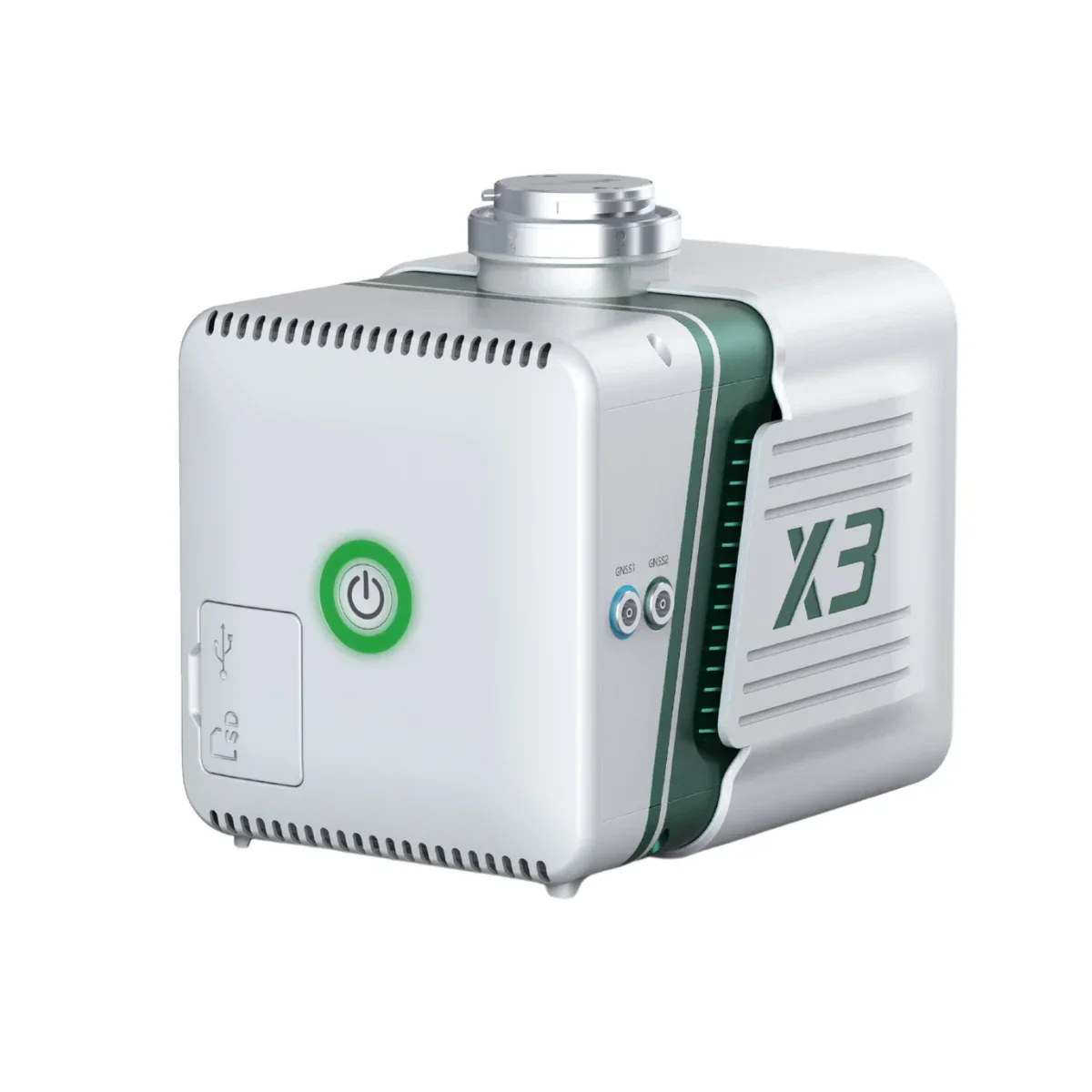
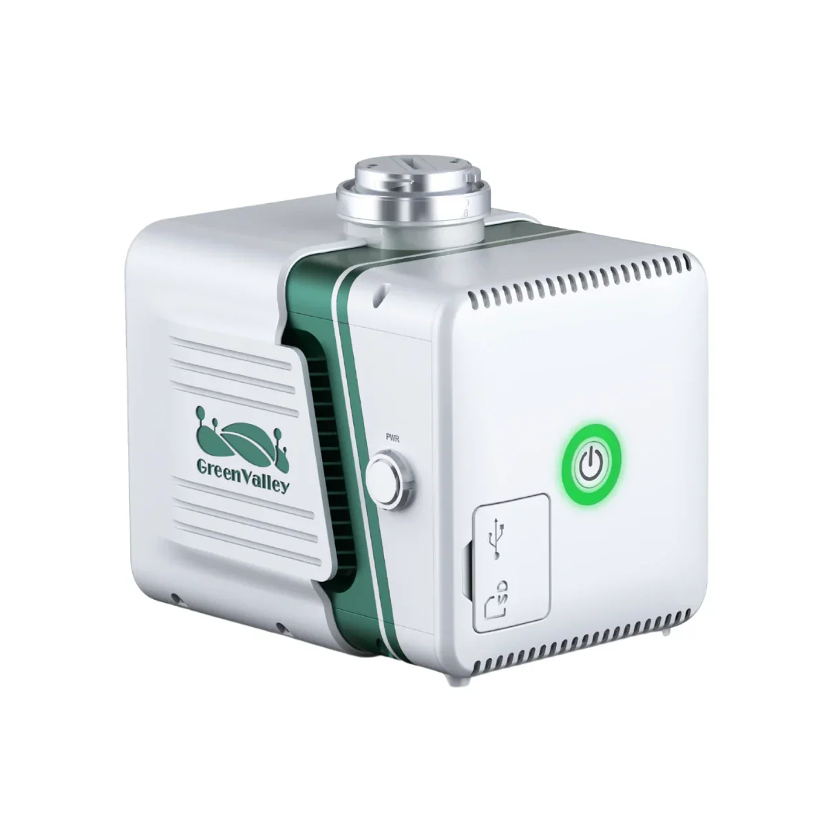
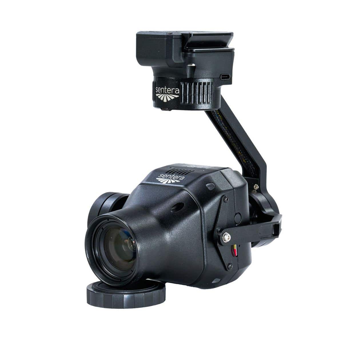
Freefly Flux H1: Highest-Accuracy LiDAR Payload in the Flux Lineup for Global Survey Operations
For survey professionals and mapping teams whose deliverable accuracy standard is the first constraint that determines payload selection, the Freefly Flux H1 is the answer the Flux lineup was built toward.
Powered by the Hesai XT-32MX (Hesai 32M) scanner, it delivers 1,920,000 points per second across a full 360°×40.3° field of view at ranges up to 300 m (984 ft), with ±1 cm accuracy and 0.5 cm precision, the tightest specifications in the Freefly Flux family.
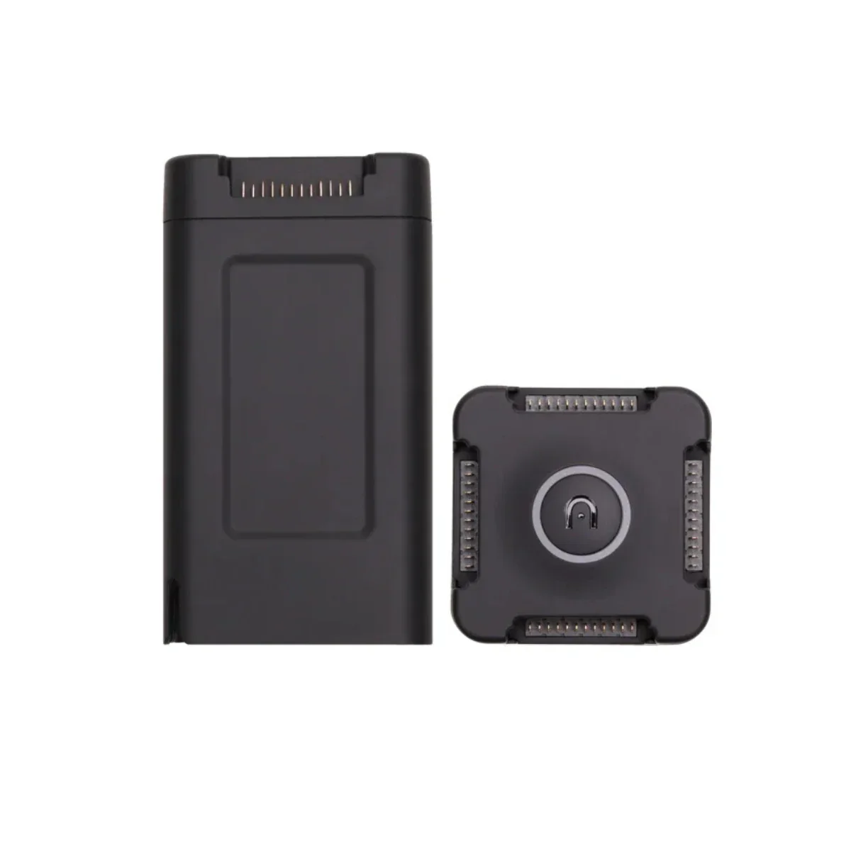
At 715 grams with an integrated Smart Dovetail mount, it connects directly to the Freefly Astro, Astro Max, and Alta X Gen2, and the zero-subscription Freefly Flow iPad workflow processes georeferenced LAS and LAZ output with no cloud dependency and no recurring cost at any stage.
Key Features and Benefits
- Hesai XT-32MX scanner: 1,920,000 points per second at ranges up to 300 m (984 ft).
- 360°×40.3° field of view: complete horizontal sweep captures every aspect in a single pass.
- ±1 cm accuracy: 0.5 cm precision — highest accuracy specification in the Flux lineup.
- Three laser returns: data fidelity through complex, layered, and partially obstructed surfaces.
- Dual U-blox X20 GNSS: full-band L1/L2/L5/L6 receivers for reliable PPK post-processing.
- Ximea 20MP RGB camera: colorizes point cloud data in the same flight pass.
- 715 g form factor: designed for maximum endurance and global field deployment.
- Smart Dovetail interface: direct tool-free integration with Astro, Astro Max, and Alta X Gen2.
- LAS and LAZ export: standard output formats with zero subscription or licensing cost.
- Free Flow app workflow: M3 iPad processes an eight-minute flight in approximately two minutes.
The H1's architecture addresses what centimeter-level accuracy actually requires in the field: a scanner capable of delivering it, a GNSS correction system capable of supporting it, and a post-processing pipeline that doesn't introduce additional error or complexity.
The dual U-blox X20 full-band receivers cover all four required correction bands — L1, L2, L5, and L6 — providing the PPK foundation that ±1 cm results depend on. Three laser returns extend data fidelity through complex and partially obstructed geometry, the integrated Ximea 20MP RGB camera colorizes the point cloud in the same pass, and the 360° horizontal sweep ensures that no aspect of a site goes uncaptured in a single flight.
For fleet operators and solutions partners deploying Freefly aircraft on high-accuracy survey programs across multiple sites or international jurisdictions, the H1 delivers consistent, portable, precision-grade performance without adding software infrastructure to the operational cost structure.
Precision-Grade Performance Designed for Global Deployment
The H1's portability is as deliberate as its accuracy. A 715 g payload that ships in a travel case and mounts via Smart Dovetail without tools or adapters is a system that travels with the operator rather than requiring advance logistics, relevant for survey programs spanning multiple regions, international contracts, and time-sensitive deployments where ground equipment setup needs to be minimal.
The dual U-blox X20 receivers are quick-release mounted, the 64 GB USB-C drive stores flight data on-device, and post-processing runs offline through the free Freefly Flow app on any Apple M-Series iPad. There is no cloud upload, no license activation, and no per-seat cost that varies with team size or geography.
For fleet integrators managing Freefly aircraft deployments across distributed operations, the H1 adds the highest-accuracy LiDAR option to the Flux ecosystem in a package that fits the operational model those deployments already use.
Freefly Flux LiDAR Payload Comparison
| Category | Flux O1 | Flux L1 | Flux H1 |
|---|---|---|---|
| Scanner | Ouster OS1 | Livox Avia | Hesai XT-32MX |
| Points / sec | 5,242,880 | 720,000 | 1,920,000 |
| Range | ~200 m | 450 m | 300 m |
| Field of view | 360° × 42.4° | 70° × 77° | 360° × 40.3° |
| Accuracy | ±3 cm | ±5 cm | ±1 cm |
| Precision | 0.5 cm | 2 cm | 0.5 cm |
| Laser returns | 2 | 3 | 3 |
| Weight | 633 g | 715 g | 715 g |
| Scan pattern | Repetitive | Non-repetitive | Repetitive |
| NDAA | Yes | No | No |
| RGB camera | Ximea 20MP | Ximea 20MP | Ximea 20MP |
Compatibility and System Integration
- Freefly Astro: native Smart Dovetail integration; GNSS mounts for Astro included in box.
- Freefly Astro Max: native Smart Dovetail integration; GNSS mounts included in box.
- Freefly Alta X Gen2: compatible with separately sold Freefly GNSS Mount.
- Freefly Flow app: free post-processing app for Apple M-Series iPads; no subscription required.
- Full-band GNSS base station: L1, L2, L5, and L6 required; dual-band will not work.
- NTRIP service: full-band equivalent accepted as base station alternative.
- LAS/LAZ output: compatible with survey, GIS, AEC, and infrastructure software platforms.
Applications and Use Cases
- High-accuracy survey and cadastral mapping: ±1 cm accuracy meets the tightest professional standards.
- AEC and as-built documentation: centimeter precision supports design integration and compliance verification.
- Infrastructure and structural inspection: 360° FOV and three returns resolve complex geometry completely.
- Global and multi-site survey programs: portable form factor and offline workflow suit international deployment.
- Terrain and topographic mapping: 300 m range and full 360° sweep support efficient high-altitude coverage.
- Corridor and linear infrastructure inspection: complete horizontal coverage captures all aspects in one pass.
- Construction progress and volumetric monitoring: 0.5 cm precision supports detailed change detection workflows.
The H1 makes the case for itself in a single line of the spec table: ±1 cm accuracy, 0.5 cm precision, 360° field of view, 715 grams, zero subscription. For Freefly platform operators who need those numbers and need them on a payload that travels as efficiently as it performs it is the payload the Flux lineup was designed to include.
Dronefly has built its expertise around matching the right sensor to the right platform for professional survey and infrastructure programs, and the Freefly Flux H1 is the natural choice for Freefly ecosystem operators whose work demands the highest accuracy available in the lineup.
When you source the Flux H1 through Dronefly, you get the configuration guidance and deployment support to ensure your aircraft, base station, and post-processing workflow are correctly aligned before your first mission.
Reach out to Dronefly today to discuss your project requirements and place your order.

Details & Craftsmanship
Every detail has been carefully considered to bring you the perfect product.

Details & Craftsmanship
Every detail has been carefully considered to bring you the perfect product.

Details & Craftsmanship
Every detail has been carefully considered to bring you the perfect product.
Description
Freefly Flux H1: Highest-Accuracy LiDAR Payload in the Flux Lineup for Global Survey Operations
For survey professionals and mapping teams whose deliverable accuracy standard is the first constraint that determines payload selection, the Freefly Flux H1 is the answer the Flux lineup was built toward.
Powered by the Hesai XT-32MX (Hesai 32M) scanner, it delivers 1,920,000 points per second across a full 360°×40.3° field of view at ranges up to 300 m (984 ft), with ±1 cm accuracy and 0.5 cm precision, the tightest specifications in the Freefly Flux family.
At 715 grams with an integrated Smart Dovetail mount, it connects directly to the Freefly Astro, Astro Max, and Alta X Gen2, and the zero-subscription Freefly Flow iPad workflow processes georeferenced LAS and LAZ output with no cloud dependency and no recurring cost at any stage.
Key Features and Benefits
- Hesai XT-32MX scanner: 1,920,000 points per second at ranges up to 300 m (984 ft).
- 360°×40.3° field of view: complete horizontal sweep captures every aspect in a single pass.
- ±1 cm accuracy: 0.5 cm precision — highest accuracy specification in the Flux lineup.
- Three laser returns: data fidelity through complex, layered, and partially obstructed surfaces.
- Dual U-blox X20 GNSS: full-band L1/L2/L5/L6 receivers for reliable PPK post-processing.
- Ximea 20MP RGB camera: colorizes point cloud data in the same flight pass.
- 715 g form factor: designed for maximum endurance and global field deployment.
- Smart Dovetail interface: direct tool-free integration with Astro, Astro Max, and Alta X Gen2.
- LAS and LAZ export: standard output formats with zero subscription or licensing cost.
- Free Flow app workflow: M3 iPad processes an eight-minute flight in approximately two minutes.
The H1's architecture addresses what centimeter-level accuracy actually requires in the field: a scanner capable of delivering it, a GNSS correction system capable of supporting it, and a post-processing pipeline that doesn't introduce additional error or complexity.
The dual U-blox X20 full-band receivers cover all four required correction bands — L1, L2, L5, and L6 — providing the PPK foundation that ±1 cm results depend on. Three laser returns extend data fidelity through complex and partially obstructed geometry, the integrated Ximea 20MP RGB camera colorizes the point cloud in the same pass, and the 360° horizontal sweep ensures that no aspect of a site goes uncaptured in a single flight.
For fleet operators and solutions partners deploying Freefly aircraft on high-accuracy survey programs across multiple sites or international jurisdictions, the H1 delivers consistent, portable, precision-grade performance without adding software infrastructure to the operational cost structure.
Precision-Grade Performance Designed for Global Deployment
The H1's portability is as deliberate as its accuracy. A 715 g payload that ships in a travel case and mounts via Smart Dovetail without tools or adapters is a system that travels with the operator rather than requiring advance logistics, relevant for survey programs spanning multiple regions, international contracts, and time-sensitive deployments where ground equipment setup needs to be minimal.
The dual U-blox X20 receivers are quick-release mounted, the 64 GB USB-C drive stores flight data on-device, and post-processing runs offline through the free Freefly Flow app on any Apple M-Series iPad. There is no cloud upload, no license activation, and no per-seat cost that varies with team size or geography.
For fleet integrators managing Freefly aircraft deployments across distributed operations, the H1 adds the highest-accuracy LiDAR option to the Flux ecosystem in a package that fits the operational model those deployments already use.
Freefly Flux LiDAR Payload Comparison
| Category | Flux O1 | Flux L1 | Flux H1 |
|---|---|---|---|
| Scanner | Ouster OS1 | Livox Avia | Hesai XT-32MX |
| Points / sec | 5,242,880 | 720,000 | 1,920,000 |
| Range | ~200 m | 450 m | 300 m |
| Field of view | 360° × 42.4° | 70° × 77° | 360° × 40.3° |
| Accuracy | ±3 cm | ±5 cm | ±1 cm |
| Precision | 0.5 cm | 2 cm | 0.5 cm |
| Laser returns | 2 | 3 | 3 |
| Weight | 633 g | 715 g | 715 g |
| Scan pattern | Repetitive | Non-repetitive | Repetitive |
| NDAA | Yes | No | No |
| RGB camera | Ximea 20MP | Ximea 20MP | Ximea 20MP |
Compatibility and System Integration
- Freefly Astro: native Smart Dovetail integration; GNSS mounts for Astro included in box.
- Freefly Astro Max: native Smart Dovetail integration; GNSS mounts included in box.
- Freefly Alta X Gen2: compatible with separately sold Freefly GNSS Mount.
- Freefly Flow app: free post-processing app for Apple M-Series iPads; no subscription required.
- Full-band GNSS base station: L1, L2, L5, and L6 required; dual-band will not work.
- NTRIP service: full-band equivalent accepted as base station alternative.
- LAS/LAZ output: compatible with survey, GIS, AEC, and infrastructure software platforms.
Applications and Use Cases
- High-accuracy survey and cadastral mapping: ±1 cm accuracy meets the tightest professional standards.
- AEC and as-built documentation: centimeter precision supports design integration and compliance verification.
- Infrastructure and structural inspection: 360° FOV and three returns resolve complex geometry completely.
- Global and multi-site survey programs: portable form factor and offline workflow suit international deployment.
- Terrain and topographic mapping: 300 m range and full 360° sweep support efficient high-altitude coverage.
- Corridor and linear infrastructure inspection: complete horizontal coverage captures all aspects in one pass.
- Construction progress and volumetric monitoring: 0.5 cm precision supports detailed change detection workflows.
The H1 makes the case for itself in a single line of the spec table: ±1 cm accuracy, 0.5 cm precision, 360° field of view, 715 grams, zero subscription. For Freefly platform operators who need those numbers and need them on a payload that travels as efficiently as it performs it is the payload the Flux lineup was designed to include.
Dronefly has built its expertise around matching the right sensor to the right platform for professional survey and infrastructure programs, and the Freefly Flux H1 is the natural choice for Freefly ecosystem operators whose work demands the highest accuracy available in the lineup.
When you source the Flux H1 through Dronefly, you get the configuration guidance and deployment support to ensure your aircraft, base station, and post-processing workflow are correctly aligned before your first mission.
Reach out to Dronefly today to discuss your project requirements and place your order.